|
Contouring
A contour line (also level
set, isopleth, isoline, isogram or isarithm) for a
function of two variables is a curve connecting points
where the function has a same particular value. A contour
map is a map illustrated with contour lines, for example a
topographic map. The prefix iso-, from the Greek prefix
?s?? ("equal"), is used from descriptive names
for map lines that join points of equal value.
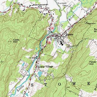
Most everyday use of the term is in cartography. A contour
map (topographic map) uses contour lines (often
just called a "contour") to join points of equal
elevation (height) and thus show valleys and hills, and
the steepness of slopes.
More generally, a contour line for a function of two
variables is a curve connecting points where the function
has a same particular value. The prefix iso-, from the
Greek prefix ?s?? ("equal"), is used from descriptive
names for map lines that join points of equal value. The
gradient of the function is always perpendicular to the
contour lines. When the lines are close together the
length of the gradient is large: the variation is steep.
If adjacent contour lines are of the same line width, the
direction of the gradient cannot be determined from the
contour lines alone. However if contour lines rotate
through three or more widths, or if the lines are
numerically labelled, then the direction of the gradient
can also be determined from the contour lines.
Contour lines are curved or straight lines on a map
describing the intersection of a real or hypothetical
surface with one or more horizontal planes. The
configuration of these contours allows map readers to
infer relative gradient of a parameter and estimate that
parameter at specific places. Contour lines may be either
traced on a visible three-dimensional model of the
surface, as when a photogrammetrist viewing a stereo-model
plots elevation contours, or interpolated from estimated
surface elevations, as when a computer program threads
contours through a network of observation points at area
centroids.
 |