|
TOPOGRAPHICAL SURVEY
Topography refers to the characteristics of the
land surface. These characteristics include relief,
natural features, and artificial (or
man-made) features. Relief is the conjuration of the
earth's surface and includes such features as hills,
valleys, plains, summits, depressions, and other natural
features, such as trees, streams, and lakes. Man-made
features are highways, bridges, dams, wharfs, buildings,
and so forth. A graphic representation of the topography
of an area is called a topographic map. A
topographic map is simply a drawing that shows the
natural and artificial features of an area. A
topographic survey is a survey conducted to obtain
the data needed for the preparation of a topographic
map. This data consists of the horizontal and vertical
locations of the features to be shown on the map.
TOPOGRAPHIC SURVEYING The fieldwork in a
topographic survey consists principally of
(1) the establishment of a basic frame-work of
horizontally and vertically located control points
(called instrument points or stations) and (2)
the determination of the horizontal and vertical
locations of details in the vicinity of each instrument
point. We will begin our discussions with topographic
control. TOPOGRAPHIC CONTROL Topographic control
consists of two parts: (1) horizontal control,
which locates the horizontally fixed position of
specified control points, and (2) vertical
control, in which the elevations of specified bench
marks are established. This control provides the
framework from which topographic details, such as roads,
buildings, rivers, and the elevation of ground points,
are located. Horizontal Control locating primary
and secondary horizontal control points or stations may
be accomplished by traversing, by triangulation or by
the combined use of both methods. On an important,
large-area survey, there may be both primary control, in
which a number of widely separated primary control
points are located with a high degree of precision; and
secondary control, in which stations are located with
less precision within the framework of the primary
control points. The routing of a primary traverse should
be considered carefully. It should follow routes that
will produce conveniently located stations. Such routes
might run along roads, ridges, valleys, edges of wooded
areas, public land lines, or near the perimeter of
tracts of land. This latter route is of particular
importance for small areas. When all the details in the
area can be conveniently located from stations on the
primary traverse, you do not need secondary traverses.
However, the size or character of the terrain or both
usually makes secondary traverses necessary. Consider,
for example, the situation shown in Figure 8-1.
This figure shows a tract bounded on three sides by
highways and on the fourth side by a fence. For
simplification, the figure shows only the items to be
discussed. An actual complete plan would include a
title, date, scale, north arrow, and so forth.
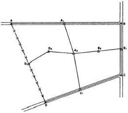
Figure 8-1: Primary
traverse and secondary traverse
|