|
Introduction
Geographic Information System (GIS) is a computer based
information system used to digitally represent and analyze
the geographic features present on the Earth's surface and
the events (non-spatial attributes linked to the geography
under study) that taking place on it. The meaning to
represent digitally is to convert analog (smooth line)
into a digital form.
Defining GIS
A GIS is an information system designed to work with data
referenced by spatial / geographical coordinates. In other
words, GIS is both a database system with specific
capabilities for spatially referenced data as well as a
set of operations for working with the data. It may also
be considered as a higher order map.
GIS technology integrates common database operations such
as query and statistical analysis with the unique
visualization and geographic analysis benefits offered by
maps. These abilities distinguish GIS from other
information systems and make it valuable to a wide range
of public and private enterprises for explaining events,
predicting outcomes, and planning strategies.
A Geographic Information System is a computer based system
which is used to digitally reproduce and analyze the
feature present on earth surface and the events that take
place on it. In the light of the fact that almost 70% of
the data has geographical reference as it's denominator,
it becomes imperative to underline the importance of a
system which can represent the given data geographically.
A typical GIS can be understood by the help of sequence
given below:
Hence GIS is looked upon as a tool to assist in
decision-making and management of attributes that needs to
be analyzed spatially.
Answers GIS can give:
Till now GIS has been described in two ways:
-
Through formal definitions, and
-
Through technology's ability to carry out spatial
operations, linking data sets together.
However there is another way to describe GIS by listing
the type of questions the technology can (or should be
able to) answer. Location, Condition, Trends, patterns,
Modelling, Aspatial questions, Spatial questions. There
are five types of questions that a sophisticated GIS can
answer:
Location What is at………….?
The first of these questions seeks to find out what exists
at a particular location. A location can be described in
many ways, using, for example place name, post code, or
geographic reference such as longitude/latitude or x/y.
Condition Where is it………….?
The second question is the converse of the first and
requires spatial data to answer. Instead of identifying
what exists at a given location, one may wish to find
location(s) where certain conditions are satisfied (e.g.,
an unforested section of at-least 2000 square meters in
size, within 100 meters of road, and with soils suitable
for supporting buildings).
Trends What has changed since…………..?
The third question might involve both the first two and
seeks to find the differences (e.g. in land use or
elevation) over time.
Modelling What if?
What if? questions are posed to determine what happens,
for example, if a new road is added to a network or if a
toxic substance seeps into the local ground water supply.
Answering this type of question requires both geographic
and other information (as well as specific models). GIS
permits spatial operation.
Spatial Questions
How many people work with GIS in the major centres of a
city "OR" Which centres lie within 20 Kms. of each other?
"OR" What is the shortest route passing through all these
centres". These are spatial questions that can only be
answered using latitude and longitude data and other
information such as the radius of earth. Geographic
Information Systems can answer such questions.
Need for GIS
Many professionals, such as foresters, urban planners, and
geologists, have recognized the importance of spatial
dimensions in organizing & analyzing information. Whether
a discipline is concerned with the very practical aspects
of business, or is concerned with purely academic
research, geographic information system can introduce a
perspective, which can provide valuable insights as:
-
70% of the information has geographic location as it's
denominator making spatial analysis an essential tool.
-
Ability to assimilate divergent sources of data both
spatial and non-spatial (attribute data).
-
Visualization Impact
-
Analytical Capability
-
Sharing of Information
Factors aiding the rise of GIS
-
Communication Technology.
-
Rapidly declining cost of Computer Hardware, and at the
same time, exponential growth of operational speed of
computers.
-
Enhanced functionality of software and their
user-friendliness.
-
Geographical feature and data describing it are part of
our everyday lives & most of our everyday decisions are
influenced by some facet of Geography.
Philosophy of GIS
The proliferation of GIS is explained by its unique
ability to assimilate data from widely divergent sources,
to analyze trends over time, and to spatially evaluate
impacts caused by development.
For an experienced analyst, GIS is an extension one's own
analytical thinking. The system has no in-built solutions
for any spatial problems; it depends upon the analyst.
The importance of different factors of GIS in decreasing
order is as under:
-
Spatial Analysis
-
Database
-
Software
-
Hardware
GIS involves complete understanding about patterns, space,
and processes or methodology needed to approach a problem.
It is a tool acting as a means to attain certain objective
quickly and efficiently. Its applicability is realized
when the user fully understands the overall spatial
concept under which a particular GIS is established and
analyses his specific application in the light of those
established parameters.
Before the GIS implementation is considered the
objectives, both immediate and long term, have to be
considered. Since the effectiveness and efficiency (i.e.
benefit against cost) of the GIS will depend largely on
the quality of initial field data captured, organizational
design has to be decided upon to maintain this data
continuously. This initial data capture is most important.
Advantages of GIS
The Geographic Information System has been an effective
tool for implementation and monitoring of municipal
infrastructure. The use of GIS has been in vogue primarily
due to the advantage mentioned below:
Planning Of Project
Advantage of GIS is often found in detailed planning of
project having a large spatial component, where analysis
of the problem is a pre requisite at the start of the
project. Thematic maps generation is possible on one or
more than one base maps, example: the generation of a land
use map on the basis of a soil composition, vegetation and
topography. The unique combination of certain features
facilitates the creation of such thematic maps. With the
various modules within GIS it is possible to calculate
surface, length, width and distance.
Making Decisions
The adage "better information leads to better decisions"
is as true for GIS as it is for other information systems.
A GIS, however, is not an automated decision making system
but a tool to query, analyze, and map data in support of
the decision making process. GIS technology has been used
to assist in tasks such as presenting information at
planning inquiries, helping resolve territorial disputes,
and siting pylons in such a way as to minimize visual
intrusion.
Visual Analysis
Digital Terrain Modeling (DTM) is an important utility of
GIS. Using DTM/3D modeling, landscape can be better
visualized, leading to a better understanding of certain
relations in the landscape. Many relevant calculations,
such as (potential) lakes and water volumes, soil erosion
volume (Example: landslides), quantities of earth to be
moved (channels, dams, roads, embankments, land leveling)
and hydrological modeling becomes easier.
Improving Organizational Integration
Many organizations that have implemented a GIS have found
that one of its main benefits is improved management of
their own organization and resources. Because GIS has the
ability to link data sets together by geography, it
facilitates interdepartmental information sharing and
communication. By creating a shared database one
department can benefit from the work of another--data can
be collected once and used many times.
As communication increases among individuals and
departments, redundancy is reduced, productivity is
enhanced, and overall organizational efficiency is
improved. Thus, in a utility company the customer and
infrastructure databases can be integrated so that when
there is planned maintenance, affected people can be
informed by computer-generated letters.
Components of GIS
GIS constitutes of five key components:
-
Hardware
-
Software
-
Data
-
People
-
Method
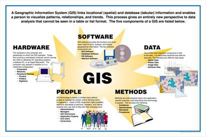
Hardware
It consists of the computer system on which the GIS
software will run. The computer forms the backbone of the
GIS hardware, which gets it's input through the Scanner or
a digitizer board. Scanner converts a picture into a
digital image for further processing. The output of
scanner can be stored in many formats e.g. TIFF, BMP, JPG
etc. Printers and plotters are the most common output
devices for a GIS hardware setup.
Software
GIS software provides the functions and tools needed to
store, analyze, and display geographic information. GIS
softwares in use are MapInfo, ARC/Info, AutoCAD Map, etc.
The software available can be said to be application
specific.
Data
Geographic data and related tabular data can be collected
in-house. The digital map forms the basic data input for
GIS. Tabular data related to the map objects can also be
attached to the digital data. A GIS will integrate spatial
data with other data resources and can even use a DBMS,
used by most organization to maintain their data, to
manage spatial data.
People
GIS users range from technical specialists who design and
maintain the system to those who use it to help them
perform their everyday work. The people who use GIS can be
broadly classified into two classes. The CAD/GIS operator,
whose work is to vectorize the map objects. The use of
this vectorized data to perform query, analysis or any
other work is the responsibility of a GIS engineer/user.
Method
And above all a successful GIS operates according to a
well-designed plan and business rules, which are the
models and operating practices unique to each
organization. There are various techniques used for map
creation and further usage for any project. The map
creation can either be automated raster to vector creator
or it can be manually vectorized using the scanned images.
The source of these digital maps can be either map
prepared by any survey agency or satellite imagery.
GIS Applications
Computerized mapping and spatial analysis have been
developed simultaneously in several related fields. The
present status would not have been achieved without close
interaction between various fields such as utility
networks, cadastral mapping, topographic mapping, thematic
cartography, surveying and photogrammetry remote sensing,
image processing, computer science, rural and urban
planning, earth science, and geography.
The GIS technology is rapidly becoming a standard tool for
management of natural resources. The effective use of
large spatial data volumes is dependent upon the existence
of an efficient geographic handling and processing system
to transform this data into usable information.
The GIS technology is used to assist decision-makers by
indicating various alternatives in development and
conservation planning and by modelling the potential
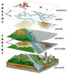
outcomes of a series of scenarios. It should be noted that
any task begins and ends with the real world. Data are
collected about the real world. Of necessity, the product
is an abstraction; it is not possible (and not desired) to
handle every last detail. After the data are analyzed,
information is compiled for decision-makers. Based on this
information, actions are taken and plans implemented in
the real world.
Major areas of application
-
Different streams of planning: Urban planning, housing,
transportation planning architectural conservation, urban
design and landscape.
-
Street Network Based Application: It is an addressed
matched application, vehicle routing and scheduling:
location and site selection and disaster planning.
-
Natural Resource Based Application: Management and
environmental impact analysis of wild and scenic
recreational resources, flood plain, wetlands, acquifers,
forests, and wildlife.
-
View Shed Analysis: Hazardous or toxic factories siting
and ground water modelling. Wild life habitat study and
migrational route planning.
-
Land Parcel Based: Zoning, sub-division plans review,
land acquisition, environment impact analysis, nature
quality management and maintenance etc.
-
Facilities Management: Can locate underground pipes and
cables for maintenance, planning, tracking energy use.
|